Geolocate

Yimbo topographic map

Click on the map to display elevation.

About this map

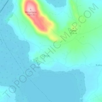
Name: Yimbo topographic map, elevation, terrain.

Location: Yimbo, Yimbo East ward, Bondo, Siaya County, Kenya (-0.04223 34.03943 -0.00223 34.07943)

Average elevation: 1,164 m

Minimum elevation: 1,136 m

Maximum elevation: 1,318 m

Other topographic maps

Click on a map to view its topography, its elevation and its terrain.

Ramogi Hills

Kenya > Siaya County > Bondo > Yimbo East ward > Yimbo

Average elevation: 1,177 m

Gear up for your next adventure:

🥾Hiking Gaiters - Protect legs and shoes from mud, snow, and debris
Bushcraft Tarp - Versatile emergency shelter or gear protection
🧰Emergency Multi-Tool - Compact multi-tool for outdoor survival
🔭Compact Monocular - One-handed bird watching and trail spotting
🧢Sun Protection Cap - Breathable cap to protect from sun exposure

As an Amazon Associate, this site earns from qualifying purchases at no extra cost to you.