Geolocate

Line topographic map

Click on the map to display elevation.

About this map

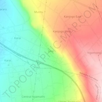
Name: Line topographic map, elevation, terrain.

Location: Line, Naivasha East ward, Naivasha, Nakuru, Rift Valley, Kenya (-0.78421 36.48243 -0.74421 36.52243)

Average elevation: 2,219 m

Minimum elevation: 2,103 m

Maximum elevation: 2,355 m

Gear up for your next adventure:

Lightweight Camping Tent - Portable shelter optimized for Canadian backcountry camping
🧥Waterproof Jacket - Lightweight rain jackets for hiking and outdoor activities
👟Sport Hiking Sandals - Breathable footwear for water crossings and camp rest
🕶️Polarized Sunglasses - Reduces glare from snow and water at high elevations
🧣Evaporative Cooling Towel - Beat the heat during intense summer climbs

As an Amazon Associate, this site earns from qualifying purchases at no extra cost to you.