
Make a donation
Gear up for your next adventure:
As an Amazon Associate, this site earns from qualifying purchases at no extra cost to you.
Le Petit Thiervoz topographic map
Click on the map to display elevation.
Make a donation
Gear up for your next adventure:
As an Amazon Associate, this site earns from qualifying purchases at no extra cost to you.
About this map
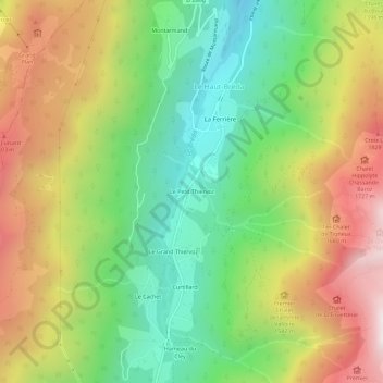
Name: Le Petit Thiervoz topographic map, elevation, terrain.
Average elevation: 1,356 m
Minimum elevation: 825 m
Maximum elevation: 2,046 m
Make a donation
Gear up for your next adventure:
As an Amazon Associate, this site earns from qualifying purchases at no extra cost to you.
Other topographic maps
Click on a map to view its topography, its elevation and its terrain.
Pinsot
France > Auvergne-Rhône-Alpes > Isère > Le Haut-Bréda
La commune de Pinsot est située au creux de la vallée du Haut Bréda dans la chaîne de Belledonne, au pied du massif du Gleyzin (2 600 m) et proche de celui des Sept Laux. Le village est situé au confluent des torrents du Bréda, du Gleyzin et du Jalon. Son altitude est de 732 mètres au niveau de…
Average elevation: 1,522 m
Make a donation
Gear up for your next adventure:
As an Amazon Associate, this site earns from qualifying purchases at no extra cost to you.