
Haparanda kommun topographic map
Interactive map
Click on the map to display elevation.
About this map
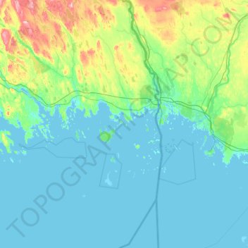
Name: Haparanda kommun topographic map, elevation, terrain.
Location: Haparanda kommun, Norrbottens län, Zweden (65.35374 23.33195 66.16782 24.17768)
Average elevation: 22 m
Minimum elevation: -4 m
Maximum elevation: 205 m
Other topographic maps
Click on a map to view its topography, its elevation and its terrain.
Kangos
Kangos, Pajala kommun, Norrbottens län, Zweden
Average elevation: 226 m