
Make a donation
Gear up for your next adventure:
As an Amazon Associate, this site earns from qualifying purchases at no extra cost to you.
Pouembout topographic map
Click on the map to display elevation.
Make a donation
Gear up for your next adventure:
As an Amazon Associate, this site earns from qualifying purchases at no extra cost to you.
Pouembout
Le massif de Kopeto constitue le point culminant de la commune avec une altitude maximale de 1 134 mètres.
Make a donation
Gear up for your next adventure:
As an Amazon Associate, this site earns from qualifying purchases at no extra cost to you.
About this map
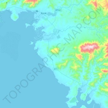
Name: Pouembout topographic map, elevation, terrain.
Average elevation: 76 m
Minimum elevation: -1 m
Maximum elevation: 1,053 m
Make a donation
Gear up for your next adventure:
As an Amazon Associate, this site earns from qualifying purchases at no extra cost to you.
Other topographic maps
Click on a map to view its topography, its elevation and its terrain.
Make a donation
Gear up for your next adventure:
As an Amazon Associate, this site earns from qualifying purchases at no extra cost to you.
Mont Panié
France > Province Nord > Hienghène
Le mont Panié, localement appelé Taaluny, est un sommet de Nouvelle-Calédonie s'élevant à 1 629 mètres d'altitude au nord de l'île de Grande Terre, dans la Chaîne centrale, et constituant le point culminant de cette collectivité d'outre-mer. Il est constitué de roches métamorphiques. Situé face aux…
Average elevation: 1,236 m