Geolocate

Sampiro topographic map

Click on the map to display elevation.

About this map

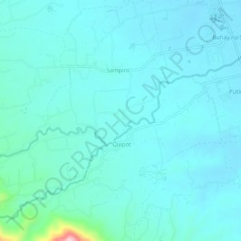
Name: Sampiro topographic map, elevation, terrain.

Location: Sampiro, San Juan, Batangas, Calabarzon, Philippines (13.75266 121.35261 13.79726 121.39531)

Average elevation: 46 m

Minimum elevation: 13 m

Maximum elevation: 306 m

Other topographic maps

Click on a map to view its topography, its elevation and its terrain.

Malaking Tubig River

Philippines > Batangas > San Juan

Average elevation: 10 m

Ticalan

Philippines > Batangas > San Juan > Ticalan

Average elevation: 8 m

Hugom

Philippines > Batangas > San Juan > Hugom

Average elevation: 76 m

Gear up for your next adventure:

🧦Crew Hiking Socks - Comfortable socks for long-distance hikes
🥘Camping Cookware Set - Compact nesting pots and pans for trail cooking
🥾Trekking Poles - Adjustable trekking poles to reduce knee stress and improve stability
🌡️Emergency Mylar Blankets - Compact thermal protection for unexpected nights outdoors
🧴Insect Repellent - Protect yourself from bugs during outdoor adventures

As an Amazon Associate, this site earns from qualifying purchases at no extra cost to you.