
Make a donation
Gear up for your next adventure:
As an Amazon Associate, this site earns from qualifying purchases at no extra cost to you.
Adam’s Peak topographic map
Click on the map to display elevation.
Make a donation
Gear up for your next adventure:
As an Amazon Associate, this site earns from qualifying purchases at no extra cost to you.
Adam’s Peak
For a long period Adam's Peak was supposed to be the highest mountain in Ceylon, but actual survey makes it only 7353 ft. above sea-level. This elevation is chiefly remarkable as the resort of pilgrims from all parts of the East. The hollow in the lofty rock that crowns the summit is said by the Brahmans to be the footstep of Siva, by the Buddhists of Buddha, by the Mahommedans of Adam, whilst the Portuguese Christians were divided between the conflicting claims of St Thomas and the eunuch of Kandake, queen of Ethiopia. The footstep is covered by a handsome roof, and is guarded by the priests of a rich monastery half-way up the mountain, who maintain a shrine on the summit of the peak.
Make a donation
Gear up for your next adventure:
As an Amazon Associate, this site earns from qualifying purchases at no extra cost to you.
About this map
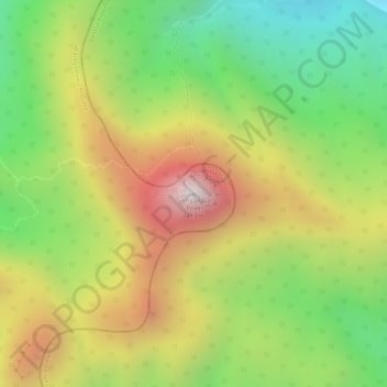
Name: Adam’s Peak topographic map, elevation, terrain.
Average elevation: 1,739 m
Minimum elevation: 1,328 m
Maximum elevation: 2,175 m
Make a donation
Gear up for your next adventure:
As an Amazon Associate, this site earns from qualifying purchases at no extra cost to you.
Other topographic maps
Click on a map to view its topography, its elevation and its terrain.
Sinharaja Forest Reserve
Sri Lanka > Sabaragamuwa Province > Palinda-Nuwara (Baduraliya) DS Division
Average elevation: 374 m
Make a donation
Gear up for your next adventure:
As an Amazon Associate, this site earns from qualifying purchases at no extra cost to you.
Sinharaja Forest Reserve
Sri Lanka > Sabaragamuwa Province > Palinda-Nuwara (Baduraliya) DS Division
Average elevation: 374 m
Sinharaja Forest Reserve
Sri Lanka > Sabaragamuwa Province > Palinda-Nuwara (Baduraliya) DS Division
Average elevation: 374 m
Make a donation
Gear up for your next adventure:
As an Amazon Associate, this site earns from qualifying purchases at no extra cost to you.
Make a donation
Gear up for your next adventure:
As an Amazon Associate, this site earns from qualifying purchases at no extra cost to you.