Geolocate

Waitati topographic map

Click on the map to display elevation.

About this map

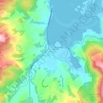
Name: Waitati topographic map, elevation, terrain.

Location: Waitati, Dunedin City, Otago, 9016, New Zealand (-45.76830 170.55036 -45.72830 170.59036)

Average elevation: 77 m

Minimum elevation: -1 m

Maximum elevation: 286 m

Other topographic maps

Click on a map to view its topography, its elevation and its terrain.

Logan Park

New Zealand > Otago > Dunedin City > Dunedin

Average elevation: 44 m

Waitati River

New Zealand > Otago > Dunedin City > Waitati

Average elevation: 259 m

Otago Harbour

New Zealand > Otago > Dunedin City > Dunedin

Average elevation: 113 m

Dunedin

New Zealand > Otago > Dunedin City

Average elevation: 143 m

Cragieburn

New Zealand > Otago > Dunedin City

Average elevation: 203 m

Gear up for your next adventure:

🧦Merino Wool Socks - Moisture-wicking comfort for long-distance hiking
🥾Light Hiking Boots - Lightweight and comfortable boots for day hikes
🧦Hiking Socks - Moisture-wicking and comfortable socks for long hikes
🛏️Camping Sleeping Mat - Comfortable mats for sleeping outdoors
Camping Essentials - All-in-one gear for a comfortable camping trip

As an Amazon Associate, this site earns from qualifying purchases at no extra cost to you.