Geolocate

Naperville topographic map

Click on the map to display elevation.

About this map

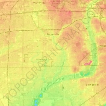
Name: Naperville topographic map, elevation, terrain.

Location: Naperville, Naperville Township, DuPage County, Illinois, United States (41.66629 -88.23535 41.82199 -88.08851)

Average elevation: 214 m

Minimum elevation: 149 m

Maximum elevation: 270 m

Other topographic maps

Click on a map to view its topography, its elevation and its terrain.

Elmhurst

United States > Illinois > DuPage County

Due to local topography, the town has had a tendency to flood in the past after large rainfalls; the city is currently undertaking a large effort to mitigate future flooding.

Average elevation: 207 m

Morton Arboretum

United States > Illinois > DuPage County > Lisle

Average elevation: 220 m

Elmhurst

United States > Illinois > DuPage County

Due to local topography, the town has had a tendency to flood in the past after large rainfalls; the city is currently undertaking a large effort to mitigate future flooding.

Average elevation: 207 m

Wheaton

United States > Illinois > DuPage County

Average elevation: 232 m

Elmhurst

United States > Illinois > DuPage County

Due to local topography, the town has had a tendency to flood in the past after large rainfalls; the city is currently undertaking a large effort to mitigate future flooding.

Average elevation: 207 m

Medinah

United States > Illinois > DuPage County

Average elevation: 225 m

Gear up for your next adventure:

🧥Waterproof Hiking Jacket - Protect yourself from rain and wind while hiking
🧢Hiking Hat - Sun-protective and breathable hats for long treks
💡LED Headlamp - Hands-free illumination for night hiking and camping
🎒Fully Waterproof Backpack - Total protection for photography gear and electronics
💧Reusable Water Bottle - Durable water bottles for hydration on trails

As an Amazon Associate, this site earns from qualifying purchases at no extra cost to you.