Geolocate

Plaridel topographic map

Click on the map to display elevation.

About this map

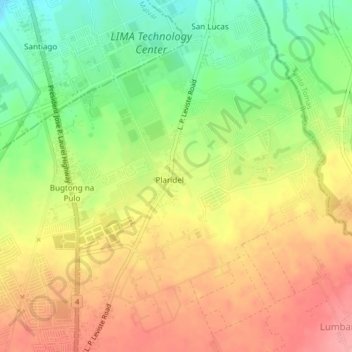
Name: Plaridel topographic map, elevation, terrain.

Location: Plaridel, Lipa, Batangas, Calabarzon, 4233, Philippines (13.98032 121.15972 14.02032 121.19972)

Average elevation: 313 m

Minimum elevation: 259 m

Maximum elevation: 360 m

Gear up for your next adventure:

🎒Backpack Rain Cover - External shield to keep your entire pack dry
🧢Outdoor Cap - Protective cap for sun and rain during hikes
👖Convertible Hiking Pants - Zip-off legs to adapt to changing weather conditions
🔥Camping Stove - Portable stoves to cook outdoors with ease
🧭GPS Handheld Device - Reliable GPS navigation for outdoor adventures

As an Amazon Associate, this site earns from qualifying purchases at no extra cost to you.