Geolocate

Coenembo topographic map

Click on the map to display elevation.

About this map

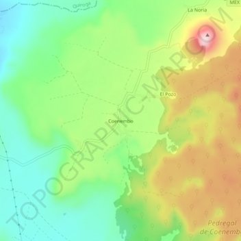
Name: Coenembo topographic map, elevation, terrain.

Location: Coenembo, Tzintzuntzan, Michoacán, 58440, Mexico (19.59904 -101.52287 19.63904 -101.48287)

Average elevation: 2,207 m

Minimum elevation: 2,078 m

Maximum elevation: 2,399 m

Gear up for your next adventure:

🛶Kayak Dry Bag - Waterproof storage for kayaking adventures
🥾Trail Hiking Shoes - Durable shoes designed for rugged trails
🌬️Windproof Camp Stove - Efficient cooking even on exposed mountain peaks
Camping Coffee Maker - Brew fresh coffee anywhere on the topographic map
🔋Emergency Crank Radio - Weather alerts and power without needing batteries

As an Amazon Associate, this site earns from qualifying purchases at no extra cost to you.