
Make a donation
Gear up for your next adventure:
As an Amazon Associate, this site earns from qualifying purchases at no extra cost to you.
Tahuata topographic map
Click on the map to display elevation.
Make a donation
Gear up for your next adventure:
As an Amazon Associate, this site earns from qualifying purchases at no extra cost to you.
Tahuata
The land area of Tahuata is 61.0 km2 (23.6 sq mi). The highest point on the island is Mount Amatea (French: Mont Amatea), rising to an elevation of 1,050 m (3,445 ft.). The island is very mountainous, with deep valleys and cliffs. The orography does not allow the construction of an airstrip and communications are by sea from the neighboring island of Hiva Oa, separated by the Bordelais channel 3 km wide and currents of 2 knots.
Make a donation
Gear up for your next adventure:
As an Amazon Associate, this site earns from qualifying purchases at no extra cost to you.
About this map
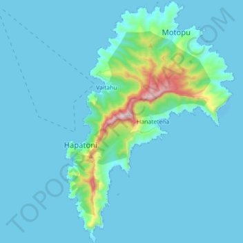
Name: Tahuata topographic map, elevation, terrain.
Average elevation: 80 m
Minimum elevation: -8 m
Maximum elevation: 918 m
Make a donation
Gear up for your next adventure:
As an Amazon Associate, this site earns from qualifying purchases at no extra cost to you.