Geolocate

Polloc topographic map

Click on the map to display elevation.

About this map

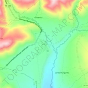
Name: Polloc topographic map, elevation, terrain.

Location: Polloc, Encañada, Cajamarca, Perú (-7.13615 -78.34656 -7.09615 -78.30656)

Average elevation: 3,026 m

Minimum elevation: 2,912 m

Maximum elevation: 3,220 m

Other topographic maps

Click on a map to view its topography, its elevation and its terrain.

Río De La Encañada

Perú > Cajamarca > Encañada > Polloc

Average elevation: 3,295 m

Laguna Azul

Perú > Cajamarca > Encañada

Average elevation: 4,024 m

Gear up for your next adventure:

Lightweight Backpacking Tent - Compact tent for efficient hiking trips
🦶Hiking Shoe Insoles - Added support for high arches and long days on feet
🛶Canoe Life Vest - Safety vest for water sports
🥾Trail Running Boots - Durable shoes designed for trail running
🥾Mountaineering Boots - Supportive boots for climbing and high-altitude hiking

As an Amazon Associate, this site earns from qualifying purchases at no extra cost to you.