
Make a donation
Gear up for your next adventure:
As an Amazon Associate, this site earns from qualifying purchases at no extra cost to you.
Nussdorf topographic map
Click on the map to display elevation.
Make a donation
Gear up for your next adventure:
As an Amazon Associate, this site earns from qualifying purchases at no extra cost to you.
Nussdorf
The municipality (Gemeinde) of Eberdingen is located at the western extremity of the district of Ludwigsburg, in the German state of Baden-Württemberg, along its border with the districts of Böblingen and the Enz. Eberdingen is physically located in the basin of [de] the Neckar. Elevation above sea level in the municipal area ranges from a high of 409 meters (1,342 ft) Normalnull (NN) to a low of 246 meters (807 ft) NN.
Make a donation
Gear up for your next adventure:
As an Amazon Associate, this site earns from qualifying purchases at no extra cost to you.
About this map
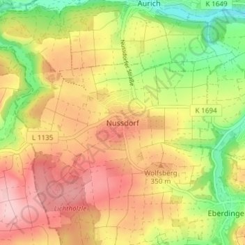
Name: Nussdorf topographic map, elevation, terrain.
Average elevation: 321 m
Minimum elevation: 219 m
Maximum elevation: 412 m
Make a donation
Gear up for your next adventure:
As an Amazon Associate, this site earns from qualifying purchases at no extra cost to you.
Other topographic maps
Click on a map to view its topography, its elevation and its terrain.
Eberdingen
Germany > Baden-Württemberg > Landkreis Ludwigsburg
The municipality (Gemeinde) of Eberdingen is located at the western extremity of the district of Ludwigsburg, in the German state of Baden-Württemberg, along its border with the districts of Böblingen and the Enz. Eberdingen is physically located in the basin of [de] the Neckar. Elevation above sea level in…
Average elevation: 332 m
Korntal-Münchingen
Germany > Baden-Württemberg > Landkreis Ludwigsburg
Korntal-Münchingen lies in the Strohgäu, at elevations between 285 and 405 meters, directly on the northwestern border of Stuttgart.
Average elevation: 320 m
Make a donation
Gear up for your next adventure:
As an Amazon Associate, this site earns from qualifying purchases at no extra cost to you.
Make a donation
Gear up for your next adventure:
As an Amazon Associate, this site earns from qualifying purchases at no extra cost to you.
Affalterbach
Germany > Baden-Württemberg > Landkreis Ludwigsburg
The municipality (Gemeinde) of Affalterbach is located at the eastern extremity of the district of Ludwigsburg, in the German state of Baden-Württemberg, along the border with the Rems-Murr district. Affalterbach lies on the Backnanger Bucht [de] in the basin of [de] the Neckar. Elevation above sea level in…
Average elevation: 285 m
Make a donation
Gear up for your next adventure:
As an Amazon Associate, this site earns from qualifying purchases at no extra cost to you.
Asperg
Germany > Baden-Württemberg > Landkreis Ludwigsburg
The city (Stadt) of Asperg covers 5.38 square kilometers (2.08 sq mi) of the district of Ludwigsburg, in Baden-Württemberg, one of the 16 States of the Federal Republic of Germany. Asperg is physically located in the basin [de] of the Neckar river. Elevation above sea level in the municipal area ranges from a…
Average elevation: 280 m
Ground Zero
Germany > Baden-Württemberg > Landkreis Ludwigsburg > Ludwigsburg
Average elevation: 304 m
Make a donation
Gear up for your next adventure:
As an Amazon Associate, this site earns from qualifying purchases at no extra cost to you.
Erdmannhausen
Germany > Baden-Württemberg > Landkreis Ludwigsburg
The municipality (Gemeinde) of Erdmannhausen is located at the eastern extremity of the district of Ludwigsburg, in the German state of Baden-Württemberg, along the border with the Rems-Murr district. Erdmannhausen is physically located in the basin of [de] the Neckar. Elevation above sea level in the…
Average elevation: 266 m
Make a donation
Gear up for your next adventure:
As an Amazon Associate, this site earns from qualifying purchases at no extra cost to you.
Vaihingen an der Enz
Germany > Baden-Württemberg > Landkreis Ludwigsburg
Vaihingen lies at an altitude of 200 to 450 metres at the end of the Strohgäus, on the western edge of the Neckarbecken in a valley widening of the Enz. The town centre lies on the east side of the river and is overlooked by the castle Kaltenstein.
Average elevation: 253 m
Kornwestheim
Germany > Baden-Württemberg > Landkreis Ludwigsburg > Kornwestheim
Average elevation: 299 m
Marbach am Neckar
Germany > Baden-Württemberg > Landkreis Ludwigsburg
The city (Stadt) of Marbach am Neckar covers 18.06 square kilometers (6.97 sq mi) of the district of Ludwigsburg in a total of four separate exclaves. Marbach is, according to government urban planning, part of the Stuttgart Metropolitan Region. Marbach's municipal areas are physically located in the basin of…
Average elevation: 251 m