
Make a donation
Gear up for your next adventure:
As an Amazon Associate, this site earns from qualifying purchases at no extra cost to you.
Campitello di Fassa topographic map
Click on the map to display elevation.
Make a donation
Gear up for your next adventure:
As an Amazon Associate, this site earns from qualifying purchases at no extra cost to you.
About this map
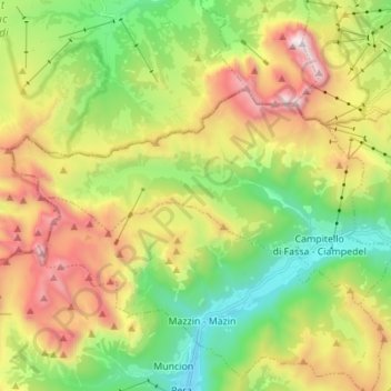
Name: Campitello di Fassa topographic map, elevation, terrain.
Average elevation: 2,070 m
Minimum elevation: 1,328 m
Maximum elevation: 3,179 m
Make a donation
Gear up for your next adventure:
As an Amazon Associate, this site earns from qualifying purchases at no extra cost to you.
Other topographic maps
Click on a map to view its topography, its elevation and its terrain.
Fontanabotte
Italië > Trentino-Zuid-Tirol > Provincia di Trento > Pergine Valsugana > Zivignago
Average elevation: 627 m
Make a donation
Gear up for your next adventure:
As an Amazon Associate, this site earns from qualifying purchases at no extra cost to you.
Passo Tonale
Italië > Trentino-Zuid-Tirol > Provincia di Trento > Vermiglio
De Tonalepas (Italiaans: Passo del Tonale) is een bergpas op de grens tussen de Italiaanse regio's Lombardije en Trentino-Alto Adige. Het is de verbinding tussen Ponte di Legno in het Val Camonica en Vermiglio in het Val di Sole. De Tonalepas is gedurende het gehele jaar berijdbaar. De pashoogte is 's winters…
Average elevation: 2,064 m
Make a donation
Gear up for your next adventure:
As an Amazon Associate, this site earns from qualifying purchases at no extra cost to you.
Make a donation
Gear up for your next adventure:
As an Amazon Associate, this site earns from qualifying purchases at no extra cost to you.
Moline
Italië > Trentino-Zuid-Tirol > Provincia di Trento > San Lorenzo in Banale
Average elevation: 952 m
Make a donation
Gear up for your next adventure:
As an Amazon Associate, this site earns from qualifying purchases at no extra cost to you.
Maso Zancanar
Italië > Trentino-Zuid-Tirol > Provincia di Trento > Nave San Felice > Maso Zancanar
Average elevation: 363 m
San Giovanni
Italië > Trentino-Zuid-Tirol > Provincia di Trento > San Giovanni di Fassa - Sèn Jan
Average elevation: 1,587 m
Make a donation
Gear up for your next adventure:
As an Amazon Associate, this site earns from qualifying purchases at no extra cost to you.