
Thank you for supporting this site ❤️
Make a donation
Make a donation
Gear up for your next adventure:
As an Amazon Associate, this site earns from qualifying purchases at no extra cost to you.
Garriguella topographic map
Click on the map to display elevation.
Thank you for supporting this site ❤️
Make a donation
Make a donation
Gear up for your next adventure:
As an Amazon Associate, this site earns from qualifying purchases at no extra cost to you.
About this map
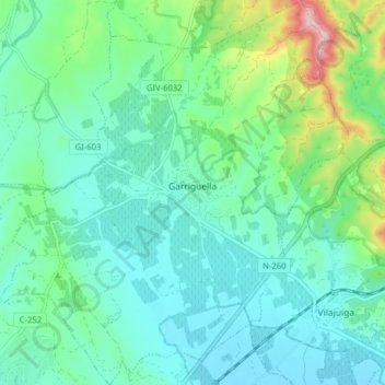
Name: Garriguella topographic map, elevation, terrain.
Location: Garriguella, Alt Empordà, Gerona, Catalonië, 17780, Spanje (42.31439 3.02460 42.37277 3.09623)
Average elevation: 76 m
Minimum elevation: 13 m
Maximum elevation: 304 m
Thank you for supporting this site ❤️
Make a donation
Make a donation
Gear up for your next adventure:
As an Amazon Associate, this site earns from qualifying purchases at no extra cost to you.
Other topographic maps
Click on a map to view its topography, its elevation and its terrain.
El Port de la Selva
Spanje > Catalonië > Alt Empordà > el Port de la Selva > El Port de la Selva
Average elevation: 76 m