Geolocate

Cimahpar topographic map

Click on the map to display elevation.

About this map

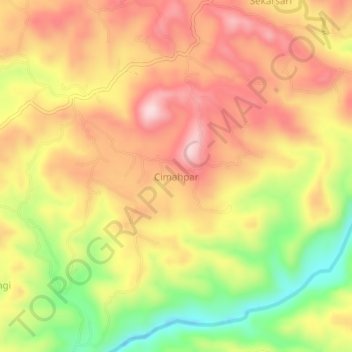
Name: Cimahpar topographic map, elevation, terrain.

Location: Cimahpar, Sukabumi, West Java, Java, Indonesia (-7.32345 106.67591 -7.28345 106.71591)

Average elevation: 246 m

Minimum elevation: 84 m

Maximum elevation: 365 m

Other topographic maps

Click on a map to view its topography, its elevation and its terrain.

Cibodas

Indonesia > West Java > Sukabumi > Cimenteng

Average elevation: 260 m

Cisolok

Indonesia > West Java > Sukabumi

Average elevation: 62 m

Cikahuripan

Indonesia > West Java > Sukabumi

Average elevation: 110 m

Gear up for your next adventure:

💡LED Camping Lantern - Illuminate your campsite with long-lasting lanterns
🩹Compact First Aid Kit - Pre-packed essentials for common trail injuries
💡Compact LED Flashlight - Powerful and portable flashlight for outdoor use
🧴Outdoor Sunscreen - High SPF protection for high-altitude UV exposure
🧦Hiking Socks - Moisture-wicking and comfortable socks for long hikes

As an Amazon Associate, this site earns from qualifying purchases at no extra cost to you.