Geolocate

Warmensteinach topographic map

Click on the map to display elevation.

About this map

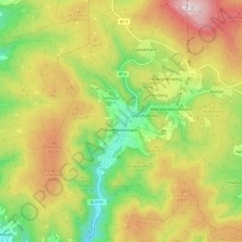
Name: Warmensteinach topographic map, elevation, terrain.

Location: Warmensteinach, Landkreis Bayreuth, Bavaria, 95485, Germany (49.96188 11.72494 50.03842 11.82846)

Average elevation: 738 m

Minimum elevation: 477 m

Maximum elevation: 1,018 m

Other topographic maps

Click on a map to view its topography, its elevation and its terrain.

Reizendorf

Germany > Bavaria > Landkreis Bayreuth > Ahorntal

Average elevation: 435 m

Pfarrhügel

Germany > Bavaria > Landkreis Bayreuth > Eckersdorf

Average elevation: 507 m

Spies

Germany > Bavaria > Landkreis Bayreuth > Betzenstein

Average elevation: 534 m

Gottelhof

Germany > Bavaria > Landkreis Bayreuth > Hollfeld

Average elevation: 407 m

Meinberg

Germany > Bavaria > Landkreis Bayreuth > Goldkronach

Average elevation: 450 m

Röhrig

Germany > Bavaria > Landkreis Bayreuth > Bindlacher Berg

Average elevation: 410 m

Gear up for your next adventure:

🚑Survival Whistle - Signal for help across long distances in mountains
🥾Lightweight Hiking Boots - Boots for comfort and mobility on long hikes
🌡️Emergency Mylar Blankets - Compact thermal protection for unexpected nights outdoors
🥾Trail Running Boots - Durable shoes designed for trail running
🪑Insulated Seat Pad - Protect your seat from cold rocks and wet logs

As an Amazon Associate, this site earns from qualifying purchases at no extra cost to you.