
Erbil topographic map
Interactive map
Click on the map to display elevation.
About this map
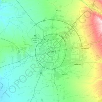
Name: Erbil topographic map, elevation, terrain.
Average elevation: 462 m
Minimum elevation: 300 m
Maximum elevation: 1,045 m
Other topographic maps
Click on a map to view its topography, its elevation and its terrain.
Cheekha Dar
Cheekha Dar, Haji Omeran Subdistrict, Choman District, Erbil Governorate, Iraqi Kurdistan Region, Iraq
Average elevation: 3,165 m
بەختیاری ٢١٤
بەختیاری ٢١٤, Erbil Central Subdistrict, Erbil District, Erbil Governorate, Iraqi Kurdistan Region, Iraq
Average elevation: 405 m