Geolocate

Kajoran topographic map

Click on the map to display elevation.

About this map

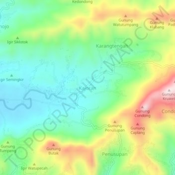
Name: Kajoran topographic map, elevation, terrain.

Location: Kajoran, Kebumen, Central Java, Java, 54364, Indonesia (-7.60886 109.58479 -7.56886 109.62479)

Average elevation: 195 m

Minimum elevation: 32 m

Maximum elevation: 486 m

Gear up for your next adventure:

🧰Emergency Multi-Tool - Compact multi-tool for outdoor survival
Camping Groundsheet - Protect your tent from moisture and dirt
🥾Trail Running Boots - Durable shoes designed for trail running
🧥Waterproof Hiking Jacket - Protect yourself from rain and wind while hiking
🧢Outdoor Visor - Breathable visor for sunny hikes

As an Amazon Associate, this site earns from qualifying purchases at no extra cost to you.