Geolocate

Riva topographic map

Click on the map to display elevation.

About this map

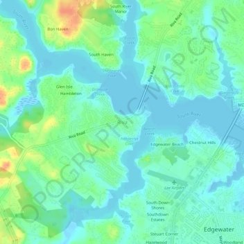
Name: Riva topographic map, elevation, terrain.

Location: Riva, Anne Arundel County, Maryland, 21041, United States (38.93206 -76.59802 38.97206 -76.55802)

Average elevation: 11 m

Minimum elevation: -4 m

Maximum elevation: 40 m

Other topographic maps

Click on a map to view its topography, its elevation and its terrain.

Pasadena

United States > Maryland > Anne Arundel County > Pasadena

Pasadena is located at 39°6′46″N 76°33′7″W / 39.11278°N 76.55194°W / 39.11278; -76.55194 (39.112809, −76.551871) in northern Anne Arundel County. It is bordered to the north by the city of Baltimore, to the east by the tidal Patapsco River and by Riviera Beach, to the southeast by Lake…

Average elevation: 13 m

Severn

United States > Maryland > Anne Arundel County > Severn

Average elevation: 47 m

Deale

United States > Maryland > Anne Arundel County > Deale

Average elevation: 5 m

Odenton

United States > Maryland > Anne Arundel County > Odenton

Average elevation: 41 m

Gear up for your next adventure:

🧣Merino Neck Gaiter - Protects against wind, sun, and cold at high altitudes
🩹Moleskin Blister Pads - Direct protection for painful foot pressure points
🥾All-Terrain Hiking Boots - Versatile boots for varied hiking conditions
🛶Waterproof Dry Bags - Keep electronics and clothes dry during river crossings
🧥Waterproof Pants - Keep dry during rainy hiking conditions

As an Amazon Associate, this site earns from qualifying purchases at no extra cost to you.