
Make a donation
Gear up for your next adventure:
As an Amazon Associate, this site earns from qualifying purchases at no extra cost to you.
New Brockton topographic map
Click on the map to display elevation.
Make a donation
Gear up for your next adventure:
As an Amazon Associate, this site earns from qualifying purchases at no extra cost to you.
About this map
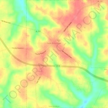
Name: New Brockton topographic map, elevation, terrain.
Location: New Brockton, Coffee County, Alabama, 36351, United States (31.35661 -85.94407 31.40512 -85.89245)
Average elevation: 122 m
Minimum elevation: 82 m
Maximum elevation: 149 m
Make a donation
Gear up for your next adventure:
As an Amazon Associate, this site earns from qualifying purchases at no extra cost to you.
Other topographic maps
Click on a map to view its topography, its elevation and its terrain.
Indian Springs
United States > Alabama > Coffee County > Enterprise > Indian Springs
Average elevation: 96 m
Valley Hills
United States > Alabama > Coffee County > Enterprise > Valley Hills
Average elevation: 109 m
Make a donation
Gear up for your next adventure:
As an Amazon Associate, this site earns from qualifying purchases at no extra cost to you.