
Wayanad District topographic map
Interactive map
Click on the map to display elevation.
About this map
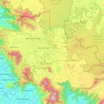
Name: Wayanad District topographic map, elevation, terrain.
Location: Wayanad District, Kerala, India (11.45136 75.77316 11.97868 76.44353)
Average elevation: 724 m
Minimum elevation: 8 m
Maximum elevation: 2,270 m
Wayanad (Malayalam: [ʋɐjɐnaːɖɨ̆]) is a district in the north-east of the Indian state of Kerala, with administrative headquarters at the municipality of Kalpetta. It is the only plateau in Kerala. The Wayanad Plateau forms a continuation of the Mysore Plateau, the southern portion of Deccan Plateau which links the Western Ghats with the Eastern Ghats. It is set high in the Western Ghats with altitudes ranging from 700 to 2100 meters. Vellari Mala, a 2,240 m (7,349 ft) high peak situated on the trijunction of Wayanad, Malappuram, and Kozhikode districts, is the highest point in Wayanad district. The district was formed on 1 November 1980 as the 12th district in Kerala, by carving out areas from Kozhikode and Kannur districts. An area of 885.92 km2 of the district is forested. Wayanad has three municipal towns—Kalpetta, Mananthavady and Sulthan Bathery. There are many indigenous tribes in this area. The Kabini River, a tributary of Kaveri River, originates at Wayanad. Wayanad district, along with the Chaliyar valley in neighbouring Nilambur (Eastern Eranad region) in Malappuram district, is known for natural gold fields, which are also seen in other parts of the Nilgiri Biosphere Reserve. Chaliyar river, which is the fourth longest river of Kerala, originates on the Wayanad plateau. The historically important Edakkal Caves are located in Wayanad district.
Other topographic maps
Click on a map to view its topography, its elevation and its terrain.
Haripad
India > Kerala > Karthikappally
Haripad, Karthikappally, Alappuzha District, Kerala, 690514, India
Average elevation: 4 m
Elimukku
India > Kerala > Kozhencherry
Elimukku, Kozhencherry, Pathanamthitta District, Kerala, 689504, India
Average elevation: 29 m
Malappuram
Malappuram, Ernad, Malappuram District, Kerala, India
Average elevation: 56 m
Sreekandapuram
India > Kerala > Taliparamba
Sreekandapuram, Taliparamba, Kannur District, Kerala, 670631, India
Average elevation: 70 m
Kadungalloor
India > Kerala > Paravur > Edayar
Kadungalloor, Edayar, Paravur, Ernakulam District, Kerala, India
Average elevation: 8 m
Mannanthala
India > Kerala > Thiruvananthapuram
Mannanthala, Thiruvananthapuram, Thiruvananthapuram District, Kerala, 695003, India
Average elevation: 51 m
Munnar Town
India > Kerala > Devikulam > Munnar
Munnar Town, Munnar, Devikulam, Idukki District, Kerala, 685612, India
Average elevation: 1,587 m
Chithirapuram
Chithirapuram, Devikulam, Idukki District, Kerala, 685565, India
Average elevation: 1,063 m
Kizhakkekallada
Kizhakkekallada, Kollam, Kollam District, Kerala, 691502, India
Average elevation: 10 m
Beericheri
Beericheri, Hosdurg, Kasaragod District, Kerala, 671311, India
Average elevation: 7 m
Vellimadukunnu
India > Kerala > Kozhikode > Kozhikode
Vellimadukunnu, Kozhikode, Kozhikode District, Kerala, India
Average elevation: 27 m
Thadiyankovval
India > Kerala > Hosdurg > Thrikaripur
Thadiyankovval, Thrikaripur, Hosdurg, Kasaragod District, Kerala, India
Average elevation: 9 m
Ondayangadi
India > Kerala > Mananthavady
Ondayangadi, Mananthavady, Wayanad District, Kerala, 670646, India
Average elevation: 783 m
Old Pambanar
India > Kerala > Peerumade > Pambanar
Old Pambanar, Pambanar, Peerumade, Idukki District, Kerala, 685537, India
Average elevation: 1,072 m
Puthuppady
India > Kerala > Kothamangalam
Puthuppady, Kothamangalam, Ernakulam District, Kerala, 686676, India
Average elevation: 27 m
Chendamangalam
Chendamangalam, Paravur, Ernakulam District, Kerala, 683512, India
Average elevation: 5 m
Aakulam park
India > Kerala > Thiruvananthapuram > Thiruvananthapuram
Aakulam park, Paruthippara, Thiruvananthapuram, Thiruvananthapuram District, Kerala, 695001, India
Average elevation: 37 m
Velli Kulangara
India > Kerala > Mukundapuram
Velli Kulangara, Mukundapuram, Thrissur District, Kerala, 680125, India
Average elevation: 8 m
Mattannur
India > Kerala > Thalassery
Mattannur, Thalassery, Kannur District, Kerala, 670702, India
Average elevation: 59 m
Neyyatinkara
India > Kerala > Neyyattinkara
Neyyatinkara, Neyyattinkara, Thiruvananthapuram District, Kerala, 695121, India
Average elevation: 38 m
Kolapra South
India > Kerala > Thodupuzha > Muttam
Kolapra South, Muttam, Thodupuzha, Idukki District, Kerala, India
Average elevation: 334 m
Thattathikanam
India > Kerala > Peerumade > Kuttikkanam
Thattathikanam, Kuttikkanam, Peerumade, Idukki District, Kerala, 685531, India
Average elevation: 993 m
Malankara Dam
India > Kerala > Thodupuzha > Muttam
Malankara Dam, Muttam, Thodupuzha, Idukki District, Kerala, 685587, India
Average elevation: 59 m
Arakuzha
India > Kerala > Muvattupuzha
Arakuzha, Muvattupuzha, Ernakulam District, Kerala, 686672, India
Average elevation: 42 m
Ayakkadu
India > Kerala > Kothamangalam
Ayakkadu, Kothamangalam, Ernakulam District, Kerala, 668892, India
Average elevation: 32 m
Kumbanad
India > Kerala > Thiruvalla
Kumbanad, Thiruvalla, Pathanamthitta District, Kerala, 689547, India
Average elevation: 24 m
Karingachira
India > Kerala > Mukundapuram > Puthenchira
Karingachira, Puthenchira, Mukundapuram, Thrissur District, Kerala, India
Average elevation: 6 m
Kuruppampady
India > Kerala > Kunnathunad
Kuruppampady, Kunnathunad, Ernakulam District, Kerala, 683545, India
Average elevation: 28 m
Airapuram
India > Kerala > Kunnathunad
Airapuram, Kunnathunad, Ernakulam District, Kerala, 683541, India
Average elevation: 26 m
Vengola
India > Kerala > Kunnathunad > Perumbavoor
Vengola, Perumbavoor, Kunnathunad, Ernakulam District, Kerala, 683500, India
Average elevation: 23 m
Nellimattom
India > Kerala > Kothamangalam
Nellimattom, Kothamangalam, Ernakulam District, Kerala, India
Average elevation: 54 m
West Kallada
West Kallada, Kunnathur, Kollam District, Kerala, 690538, India
Average elevation: 8 m
Chirakkara
Chirakkara, Kollam, Kollam District, Kerala, 691578, India
Average elevation: 36 m
Konathukunnu
India > Kerala > Mukundapuram
Konathukunnu, Mukundapuram, Thrissur District, Kerala, 680123, India
Average elevation: 9 m