
Buckfastleigh topographic map
Interactive map
Click on the map to display elevation.
About this map
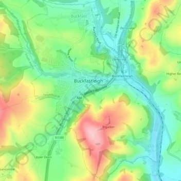
Name: Buckfastleigh topographic map, elevation, terrain.
Location: Buckfastleigh, Teignbridge, Devon, Angleterre, Royaume-Uni (50.46337 -3.79825 50.49562 -3.75766)
Average elevation: 85 m
Minimum elevation: 18 m
Maximum elevation: 189 m
Other topographic maps
Click on a map to view its topography, its elevation and its terrain.
Water
Royaume-Uni > Angleterre > Devon > Teignbridge
Water, Teignbridge, Devon, Angleterre, TQ13 9UE, Royaume-Uni
Average elevation: 261 m
Teignmouth
Royaume-Uni > Angleterre > Devon > Teignbridge
Teignmouth, Teignbridge, Devon, Angleterre, Royaume-Uni
Average elevation: 59 m