
Lourdes topographic map
Click on the map to display elevation.
About this map
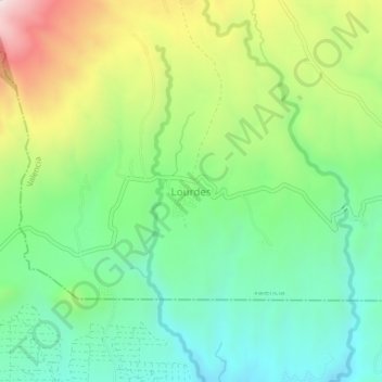
Name: Lourdes topographic map, elevation, terrain.
Location: Lourdes, Valencia, Bukidnon, Northern Mindanao, Philippines (7.87568 124.93150 7.91568 124.97150)
Average elevation: 911 m
Minimum elevation: 638 m
Maximum elevation: 1,421 m
Other topographic maps
Click on a map to view its topography, its elevation and its terrain.
Lake Apo
Philippines > Bukidnon > Valencia
Lake Apo is a crater lake in Barangay Guinoyoran in the city of Valencia in Bukidnon province in the Philippines. It is located in a hilly area about 640 metres (2,100 ft) in elevation, about 11 kilometres (6.8 mi) WSW of the city poblacion (town center). Lake Apo was awarded the cleanest inland body of water…
Average elevation: 643 m