
Make a donation
Gear up for your next adventure:
As an Amazon Associate, this site earns from qualifying purchases at no extra cost to you.
Gladenbach topographic map
Click on the map to display elevation.
Make a donation
Gear up for your next adventure:
As an Amazon Associate, this site earns from qualifying purchases at no extra cost to you.
Gladenbach
In den Gemarkungen der südlichen Stadtteile Weidenhausen, Erdhausen, Gladenbach und Mornshausen fließt von Westen die auf dem Gebiet der Gemeinde Bad Endbach entspringende Salzböde durch das Stadtgebiet und dann östlich weiter in die Gemeinden Lohra, Fronhausen und Lollar, wo sie bei Odenhausen in die Lahn mündet. Die Gemarkungen der weiter nördlich gelegenen Stadtteile Runzhausen, Bellnhausen, Sinkershausen, Frohnhausen und Friebertshausen durchquert ebenfalls weitgehend west-östlich die Allna, die im weiteren Verlauf im Gebiet der Gemeinde Weimar (Lahn) dann bereits oberhalb der Salzböde in die Lahn mündet. Weitershausen liegt am wichtigsten Allna-Zufluss Ohe. Beide Flussläufe sind durch Höhenrücken auch in ihrem jeweiligen Einzugsgebiet für kleinere Zuflüsse deutlich voneinander getrennt.
Make a donation
Gear up for your next adventure:
As an Amazon Associate, this site earns from qualifying purchases at no extra cost to you.
About this map
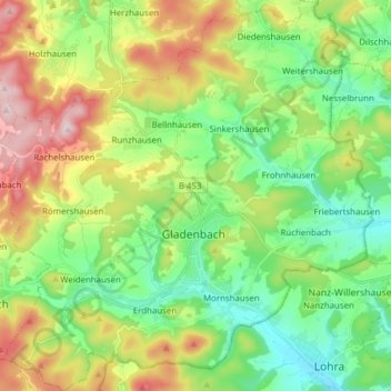
Name: Gladenbach topographic map, elevation, terrain.
Average elevation: 325 m
Minimum elevation: 201 m
Maximum elevation: 544 m
Make a donation
Gear up for your next adventure:
As an Amazon Associate, this site earns from qualifying purchases at no extra cost to you.
Other topographic maps
Click on a map to view its topography, its elevation and its terrain.