Geolocate

Angin topographic map

Click on the map to display elevation.

About this map

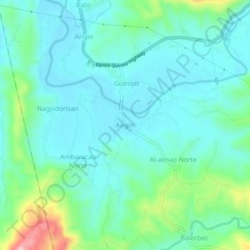
Name: Angin topographic map, elevation, terrain.

Location: Angin, Naguilian, La Union, Ilocos Region, 2511, Philippines (16.48001 120.39051 16.52001 120.43051)

Average elevation: 59 m

Minimum elevation: 13 m

Maximum elevation: 230 m

Gear up for your next adventure:

🧴Insect Repellent - Protect yourself from bugs during outdoor adventures
👖Convertible Hiking Pants - Zip-off legs to adapt to changing weather conditions
🧦Outdoor Socks - Durable socks designed for hiking and outdoor sports
🦟Insect Repellent - Keep mosquitoes and black flies away in wooded areas
🔥Emergency Fire Starter - Reliable ignition source for all weather conditions

As an Amazon Associate, this site earns from qualifying purchases at no extra cost to you.