Geolocate

Santa Lucia topographic map

Click on the map to display elevation.

About this map

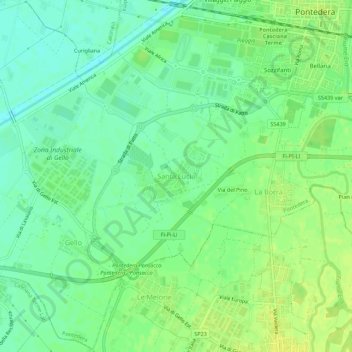
Name: Santa Lucia topographic map, elevation, terrain.

Location: Santa Lucia, Pontedera, Pisa, Tuscany, 56038, Italy (43.62474 10.59363 43.66474 10.63363)

Average elevation: 15 m

Minimum elevation: 5 m

Maximum elevation: 25 m

Gear up for your next adventure:

Backpacking Tent - Lightweight tent for long-distance hiking trips
🛶Canoe Life Vest - Safety vest for water sports
🧦Outdoor Socks - Durable socks designed for hiking and outdoor sports
Camping Groundsheet - Protect your tent from moisture and dirt
🕶️Polarized Sunglasses - Reduces glare from snow and water at high elevations

As an Amazon Associate, this site earns from qualifying purchases at no extra cost to you.