
Make a donation
Gear up for your next adventure:
As an Amazon Associate, this site earns from qualifying purchases at no extra cost to you.
Langenwetzendorf topographic map
Click on the map to display elevation.
Make a donation
Gear up for your next adventure:
As an Amazon Associate, this site earns from qualifying purchases at no extra cost to you.
Langenwetzendorf
Einmal im Jahr findet das Parkfest statt. Es handelt sich dabei um ein Volksfest mit über 50-jähriger Tradition, das von den Vereinen der Gemeinde mitgestaltet wird. Als fester Termin hat sich das zweite Wochenende im Juli etabliert. Zum Abschluss des Parkfestes gibt es seit ein paar Jahren ein Höhenfeuerwerk vor der Kulisse des Parkteiches.
Make a donation
Gear up for your next adventure:
As an Amazon Associate, this site earns from qualifying purchases at no extra cost to you.
About this map
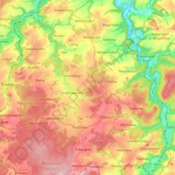
Name: Langenwetzendorf topographic map, elevation, terrain.
Location: Langenwetzendorf, Greiz, Thüringen, 07957, Deutschland (50.62264 12.03097 50.74414 12.16644)
Average elevation: 362 m
Minimum elevation: 227 m
Maximum elevation: 480 m
Make a donation
Gear up for your next adventure:
As an Amazon Associate, this site earns from qualifying purchases at no extra cost to you.
Other topographic maps
Click on a map to view its topography, its elevation and its terrain.