
Thank you for supporting this site ❤️
Make a donation
Make a donation
Gear up for your next adventure:
As an Amazon Associate, this site earns from qualifying purchases at no extra cost to you.
Mount Camiguin topographic map
Click on the map to display elevation.
Thank you for supporting this site ❤️
Make a donation
Make a donation
Gear up for your next adventure:
As an Amazon Associate, this site earns from qualifying purchases at no extra cost to you.
Mount Camiguin
The well-forested Mount Camiguin or Camiguin de Babuyanes has an elevation of 712 metres (2,336 ft) asl, and a base diameter of 3,200 metres (10,500 ft). It occupies the southwest tip of 22 km (14 mi) long Camiguin Island.
Thank you for supporting this site ❤️
Make a donation
Make a donation
Gear up for your next adventure:
As an Amazon Associate, this site earns from qualifying purchases at no extra cost to you.
About this map
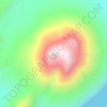
Name: Mount Camiguin topographic map, elevation, terrain.
Average elevation: 288 m
Minimum elevation: 0 m
Maximum elevation: 684 m
Thank you for supporting this site ❤️
Make a donation
Make a donation
Gear up for your next adventure:
As an Amazon Associate, this site earns from qualifying purchases at no extra cost to you.