
Make a donation
Gear up for your next adventure:
As an Amazon Associate, this site earns from qualifying purchases at no extra cost to you.
Elkhorn Peak topographic map
Click on the map to display elevation.
Make a donation
Gear up for your next adventure:
As an Amazon Associate, this site earns from qualifying purchases at no extra cost to you.
About this map
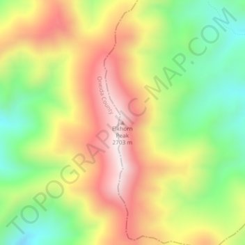
Name: Elkhorn Peak topographic map, elevation, terrain.
Location: Elkhorn Peak, Bannock County, Idaho, United States (42.33653 -112.32807 42.33663 -112.32797)
Average elevation: 2,434 m
Minimum elevation: 2,136 m
Maximum elevation: 2,749 m
Make a donation
Gear up for your next adventure:
As an Amazon Associate, this site earns from qualifying purchases at no extra cost to you.
Other topographic maps
Click on a map to view its topography, its elevation and its terrain.
Lava Hot Springs
United States > Idaho > Bannock County
Lava Hot Springs is located at 42°37′10″N 112°0′51″W / 42.61944°N 112.01417°W / 42.61944; -112.01417 (42.619482, -112.014283), at an elevation of 5,020 feet (1,530 m) above sea level.
Average elevation: 1,611 m
Make a donation
Gear up for your next adventure:
As an Amazon Associate, this site earns from qualifying purchases at no extra cost to you.