
Make a donation
Gear up for your next adventure:
As an Amazon Associate, this site earns from qualifying purchases at no extra cost to you.
Varages topographic map
Click on the map to display elevation.
Make a donation
Gear up for your next adventure:
As an Amazon Associate, this site earns from qualifying purchases at no extra cost to you.
About this map
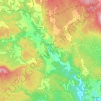
Name: Varages topographic map, elevation, terrain.
Average elevation: 396 m
Minimum elevation: 231 m
Maximum elevation: 593 m
Make a donation
Gear up for your next adventure:
As an Amazon Associate, this site earns from qualifying purchases at no extra cost to you.
Other topographic maps
Click on a map to view its topography, its elevation and its terrain.
Le Corps-de-Ville
Frankrijk > Provence-Alpes-Côte d'Azur > Var > Plan-d'Aups-Sainte-Baume
Average elevation: 728 m
Make a donation
Gear up for your next adventure:
As an Amazon Associate, this site earns from qualifying purchases at no extra cost to you.
Le Canadel
Frankrijk > Provence-Alpes-Côte d'Azur > Var > Rayol-Canadel-sur-Mer
Average elevation: 135 m
Make a donation
Gear up for your next adventure:
As an Amazon Associate, this site earns from qualifying purchases at no extra cost to you.
Les Hautes Mûres
Frankrijk > Provence-Alpes-Côte d'Azur > Var > Grimaud > Les Hautes Mûres
Average elevation: 108 m