Geolocate

Le Rouget topographic map

Click on the map to display elevation.

About this map

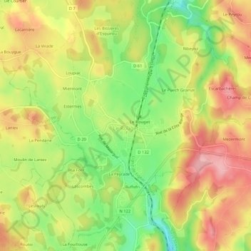
Name: Le Rouget topographic map, elevation, terrain.

Location: Le Rouget, Le Rouget-Pers, Aurillac, Cantal, Auvergne-Rhône-Alpes, France métropolitaine, 15290, France (44.83726 2.20840 44.87306 2.26056)

Average elevation: 611 m

Minimum elevation: 536 m

Maximum elevation: 676 m

Other topographic maps

Click on a map to view its topography, its elevation and its terrain.

Selves

France > Auvergne-Rhône-Alpes > Cantal > Le Rouget-Pers > Pers

Average elevation: 573 m

Le Mieulet

France > Auvergne-Rhône-Alpes > Cantal > Le Rouget-Pers > Pers

Average elevation: 552 m

Carsac

France > Auvergne-Rhône-Alpes > Cantal > Le Rouget-Pers > Pers

Average elevation: 585 m

Gear up for your next adventure:

🔋Solar Power Bank - Keep your GPS and devices charged during long outdoor trips
🛁Quick-Dry Microfiber Towel - Space-saving towel that dries rapidly on the move
🧴Bear Spray Holster - Quick-access carry for essential Canadian wilderness safety
🥾Lightweight Hiking Boots - Boots for comfort and mobility on long hikes
🧴First Aid Kit - Essential first aid supplies for outdoor emergencies

As an Amazon Associate, this site earns from qualifying purchases at no extra cost to you.