Geolocate

Gunung Merapi topographic map

Click on the map to display elevation.

About this map

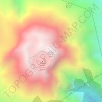
Name: Gunung Merapi topographic map, elevation, terrain.

Location: Gunung Merapi, Banyuwangi, East Java, Java, Indonesia (-8.06270 114.26189 -8.06260 114.26199)

Average elevation: 2,297 m

Minimum elevation: 1,603 m

Maximum elevation: 2,773 m

Other topographic maps

Click on a map to view its topography, its elevation and its terrain.

DESA KALIPAIT

Indonesia > East Java > Banyuwangi

Average elevation: 47 m

DESA SUMBERASRI

Indonesia > East Java > Banyuwangi

Average elevation: 13 m

Gear up for your next adventure:

💧Filtered Water Bottle - Safe drinking water on the go
🏕️Camping Hammock - Integrated protection for sleeping between trees
Backpacking Tent - Lightweight tent for long-distance hiking trips
🥾Lightweight Hiking Shoes - Comfortable shoes for day hikes
💡LED Camping Lantern - Illuminate your campsite with long-lasting lanterns

As an Amazon Associate, this site earns from qualifying purchases at no extra cost to you.