Geolocate

Schkeuditz topographic map

Click on the map to display elevation.

About this map

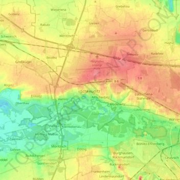
Name: Schkeuditz topographic map, elevation, terrain.

Location: Schkeuditz, Nordsachsen, Saxony, 04435, Germany (51.33255 12.17243 51.46165 12.35464)

Average elevation: 116 m

Minimum elevation: 83 m

Maximum elevation: 148 m

Gear up for your next adventure:

🔦UV Flashlight - Detect minerals or specific insects in the dark
Camping Coffee Maker - Brew fresh coffee anywhere on the topographic map
🛶Waterproof Dry Bags - Keep electronics and clothes dry during river crossings
🛏️Camping Sleeping Mat - Comfortable mats for sleeping outdoors
🧢Beanie Hat - Keep your head warm in cold weather

As an Amazon Associate, this site earns from qualifying purchases at no extra cost to you.