Geolocate

Maceió topographic map

Click on the map to display elevation.

About this map
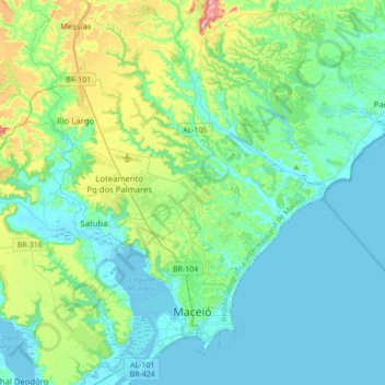
Name: Maceió topographic map, elevation, terrain.

Location: Maceió, Região Geográfica Imediata de Maceió, Região Geográfica Intermediária de Maceió, Alagoas, Northeast Region, Brazil (-9.71314 -35.81435 -9.37100 -35.55833)

Average elevation: 54 m

Minimum elevation: -3 m

Maximum elevation: 280 m

Other topographic maps

Click on a map to view its topography, its elevation and its terrain.

Pastoral

Brazil > Alagoas > Olho d'Água do Casado

Average elevation: 240 m

Barra Nova

Brazil > Alagoas > Marechal Deodoro

Average elevation: 10 m

Gear up for your next adventure:

🔨Vehicle Emergency Tool - Safety tool for remote road trips to trailheads
🧭Orienteering Kit - Tools for map reading and navigation in the wild
⛺Bushcraft Tarp - Versatile emergency shelter or gear protection
🔋Emergency Crank Radio - Weather alerts and power without needing batteries
🥾Hiking Shorts - Breathable shorts suitable for summer hikes

As an Amazon Associate, this site earns from qualifying purchases at no extra cost to you.