Geolocate

Sassafras topographic map

Click on the map to display elevation.

About this map

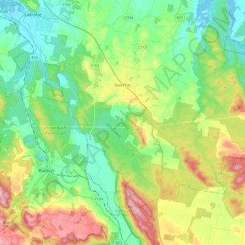
Name: Sassafras topographic map, elevation, terrain.

Location: Sassafras, Latrobe, Tasmania, 7307, Australia (-41.38089 146.43386 -41.24174 146.66425)

Average elevation: 118 m

Minimum elevation: 0 m

Maximum elevation: 357 m

Other topographic maps

Click on a map to view its topography, its elevation and its terrain.

Frog Hill

Australia > Tasmania

Average elevation: 875 m

Mount Kate

Australia > Tasmania

Average elevation: 995 m

Tasman Peninsula

Australia > Tasmania > Tasman > Fortescue

Average elevation: 167 m

Mount Jukes

Australia > Tasmania

Average elevation: 773 m

Ulverstone

Australia > Tasmania > Ulverstone

Average elevation: 37 m

Bullock Hill

Australia > Tasmania > Grove

Average elevation: 147 m

Highland Waters

Australia > Tasmania > London Lakes

Average elevation: 759 m

Stillwater Hill

Australia > Tasmania

Average elevation: 353 m

Legges Tor

Australia > Tasmania

Average elevation: 1,457 m

Rowlands Hill

Australia > Tasmania

Average elevation: 388 m

Recherche Bay

Australia > Tasmania

Average elevation: 10 m

Bastyan Dam

Australia > Tasmania > Tullah

Average elevation: 233 m

Gear up for your next adventure:

💧Filtered Water Bottle - Safe drinking water on the go
🧦Crew Hiking Socks - Comfortable socks for long-distance hikes
🥤Collapsible Travel Cup - Saves space and weight in your mess kit
Camping Groundsheet - Protect your tent from moisture and dirt
🪑Ultralight Camping Stool - Compact seating for rest stops during long hikes

As an Amazon Associate, this site earns from qualifying purchases at no extra cost to you.