
Thank you for supporting this site ❤️
Make a donation
Make a donation
Gear up for your next adventure:
As an Amazon Associate, this site earns from qualifying purchases at no extra cost to you.
Ísafjörður topographic map
Click on the map to display elevation.
Thank you for supporting this site ❤️
Make a donation
Make a donation
Gear up for your next adventure:
As an Amazon Associate, this site earns from qualifying purchases at no extra cost to you.
About this map
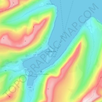
Name: Ísafjörður topographic map, elevation, terrain.
Location: Ísafjörður, Ísafjarðarbær, Westfjords Region, 400, Iceland (66.03269 -23.15935 66.11269 -23.07935)
Average elevation: 237 m
Minimum elevation: -6 m
Maximum elevation: 818 m
Thank you for supporting this site ❤️
Make a donation
Make a donation
Gear up for your next adventure:
As an Amazon Associate, this site earns from qualifying purchases at no extra cost to you.