Geolocate

Crowhurst topographic map

Click on the map to display elevation.

About this map

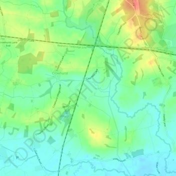
Name: Crowhurst topographic map, elevation, terrain.

Location: Crowhurst, Tandridge, Surrey, England, United Kingdom (51.18682 -0.03155 51.22272 0.02864)

Average elevation: 62 m

Minimum elevation: 42 m

Maximum elevation: 97 m

Other topographic maps

Click on a map to view its topography, its elevation and its terrain.

Starborough Castle

United Kingdom > England > Surrey > Tandridge

Average elevation: 58 m

Gear up for your next adventure:

🧊Insulated Water Bottle - Keeps drinks cold in summer and prevents freezing in winter
🥾Lightweight Hiking Boots - Boots for comfort and mobility on long hikes
🐕Hiking Dog Pack - Let your canine companion carry their own water and food
🦟Insect Repellent - Keep mosquitoes and black flies away in wooded areas
Family Camping Tent - Spacious tent suitable for family camping trips

As an Amazon Associate, this site earns from qualifying purchases at no extra cost to you.