
Make a donation
Gear up for your next adventure:
As an Amazon Associate, this site earns from qualifying purchases at no extra cost to you.
Prugovac topographic map
Click on the map to display elevation.
Make a donation
Gear up for your next adventure:
As an Amazon Associate, this site earns from qualifying purchases at no extra cost to you.
About this map
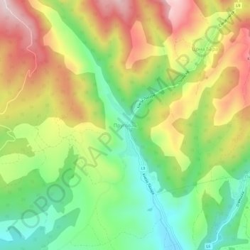
Name: Prugovac topographic map, elevation, terrain.
Average elevation: 436 m
Minimum elevation: 265 m
Maximum elevation: 645 m
Make a donation
Gear up for your next adventure:
As an Amazon Associate, this site earns from qualifying purchases at no extra cost to you.
Other topographic maps
Click on a map to view its topography, its elevation and its terrain.
Donji Krupac
Serbia > Central Serbia > Nisava Administrative District > Aleksinac Municipality
Average elevation: 303 m
Donje Suhotno
Serbia > Central Serbia > Nisava Administrative District > Aleksinac Municipality
Average elevation: 258 m
Gornje Suhotno
Serbia > Central Serbia > Nisava Administrative District > Aleksinac Municipality
Average elevation: 297 m
Locika
Serbia > Central Serbia > Nisava Administrative District > Aleksinac Municipality
Average elevation: 260 m
Make a donation
Gear up for your next adventure:
As an Amazon Associate, this site earns from qualifying purchases at no extra cost to you.
Mozgovo
Serbia > Central Serbia > Nisava Administrative District > Aleksinac Municipality
Average elevation: 426 m