
Make a donation
Gear up for your next adventure:
As an Amazon Associate, this site earns from qualifying purchases at no extra cost to you.
Jura topographic map
Click on the map to display elevation.
Make a donation
Gear up for your next adventure:
As an Amazon Associate, this site earns from qualifying purchases at no extra cost to you.
Jura
The climate of the Jura varies greatly by elevation. The lower valleys are temperate and pleasant, but the high mountain valleys have bitterly cold winters.
Make a donation
Gear up for your next adventure:
As an Amazon Associate, this site earns from qualifying purchases at no extra cost to you.
About this map
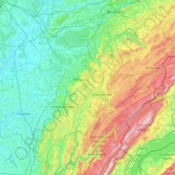
Name: Jura topographic map, elevation, terrain.
Location: Jura, Bourgogne – Franche-Comté, Metropolitan France, France (46.26102 5.25202 47.30576 6.20739)
Average elevation: 509 m
Minimum elevation: 174 m
Maximum elevation: 1,703 m
Make a donation
Gear up for your next adventure:
As an Amazon Associate, this site earns from qualifying purchases at no extra cost to you.
Other topographic maps
Click on a map to view its topography, its elevation and its terrain.
Make a donation
Gear up for your next adventure:
As an Amazon Associate, this site earns from qualifying purchases at no extra cost to you.
Les Loges de Vandenesse
France > Bourgogne – Franche-Comté > Nièvre > Saint-Honoré-les-Bains
Average elevation: 262 m
Make a donation
Gear up for your next adventure:
As an Amazon Associate, this site earns from qualifying purchases at no extra cost to you.
La Croix
France > Bourgogne – Franche-Comté > Saône-et-Loire > Saint-Sernin-du-Bois
Average elevation: 445 m
L'Enclose
France > Bourgogne – Franche-Comté > Haute-Saône > Servance-Miellin
Average elevation: 566 m
Make a donation
Gear up for your next adventure:
As an Amazon Associate, this site earns from qualifying purchases at no extra cost to you.
Le Reux
France > Bourgogne – Franche-Comté > Nièvre > Saint-Honoré-les-Bains > Tussy
Average elevation: 354 m
Make a donation
Gear up for your next adventure:
As an Amazon Associate, this site earns from qualifying purchases at no extra cost to you.
Jardins de l'Hôtel du Département
France > Bourgogne – Franche-Comté > Jura > Lons-le-Saunier
Average elevation: 299 m
Dardy
France > Bourgogne – Franche-Comté > Saône-et-Loire > Saint-Pierre-le-Vieux
Average elevation: 486 m
Make a donation
Gear up for your next adventure:
As an Amazon Associate, this site earns from qualifying purchases at no extra cost to you.
Make a donation
Gear up for your next adventure:
As an Amazon Associate, this site earns from qualifying purchases at no extra cost to you.
Bierre en Morvan
France > Bourgogne – Franche-Comté > Côte-d'Or > La Roche-en-Brenil
Average elevation: 385 m
Make a donation
Gear up for your next adventure:
As an Amazon Associate, this site earns from qualifying purchases at no extra cost to you.
Le Tertre
France > Bourgogne – Franche-Comté > Haute-Saône > Amont-et-Effreney
Average elevation: 504 m
Make a donation
Gear up for your next adventure:
As an Amazon Associate, this site earns from qualifying purchases at no extra cost to you.
Make a donation
Gear up for your next adventure:
As an Amazon Associate, this site earns from qualifying purchases at no extra cost to you.
Verdin
France > Bourgogne – Franche-Comté > Saône-et-Loire > Montagny-près-Louhans
Average elevation: 199 m
Château d'Estours
France > Bourgogne – Franche-Comté > Saône-et-Loire > Crêches-sur-Saône > Estours
Average elevation: 183 m
Le Potin
France > Bourgogne – Franche-Comté > Nièvre > Châteauneuf-Val-de-Bargis
Average elevation: 300 m
Make a donation
Gear up for your next adventure:
As an Amazon Associate, this site earns from qualifying purchases at no extra cost to you.
Saint-Valère
France > Bourgogne – Franche-Comté > Haute-Saône > Port-sur-Saône
Average elevation: 245 m
Make a donation
Gear up for your next adventure:
As an Amazon Associate, this site earns from qualifying purchases at no extra cost to you.
Le Cailleret
France > Bourgogne – Franche-Comté > Côte-d'Or > Puligny-Montrachet
Average elevation: 276 m
La Roche d'Amont
France > Bourgogne – Franche-Comté > Haute-Saône > Haut-du-Them
Average elevation: 590 m
Make a donation
Gear up for your next adventure:
As an Amazon Associate, this site earns from qualifying purchases at no extra cost to you.
Make a donation
Gear up for your next adventure:
As an Amazon Associate, this site earns from qualifying purchases at no extra cost to you.
Les Creux Bréçons
France > Bourgogne – Franche-Comté > Saône-et-Loire > Toulon-sur-Arroux
Average elevation: 284 m
Mont Auxois
France > Bourgogne – Franche-Comté > Côte-d'Or > Alise-Sainte-Reine
Average elevation: 307 m
Abbaye en Grandvaux
France > Bourgogne – Franche-Comté > Jura > Grande-Rivière-Château
Average elevation: 956 m
Make a donation
Gear up for your next adventure:
As an Amazon Associate, this site earns from qualifying purchases at no extra cost to you.
La Vieille Voie
France > Bourgogne – Franche-Comté > Haute-Saône > Corravillers
Average elevation: 593 m
Au Faubourg
France > Bourgogne – Franche-Comté > Côte-d'Or > Flavigny-sur-Ozerain
Average elevation: 379 m
Make a donation
Gear up for your next adventure:
As an Amazon Associate, this site earns from qualifying purchases at no extra cost to you.
La Ferdière du Bas
France > Bourgogne – Franche-Comté > Saône-et-Loire > Navour-sur-Grosne
Average elevation: 363 m
Auvillard
France > Bourgogne – Franche-Comté > Côte-d'Or > Saint-Victor-sur-Ouche
Average elevation: 438 m
Make a donation
Gear up for your next adventure:
As an Amazon Associate, this site earns from qualifying purchases at no extra cost to you.
Les Grandes Vignes
France > Bourgogne – Franche-Comté > Saône-et-Loire > Prissé
Average elevation: 244 m