Geolocate

Alagao topographic map

Click on the map to display elevation.

About this map

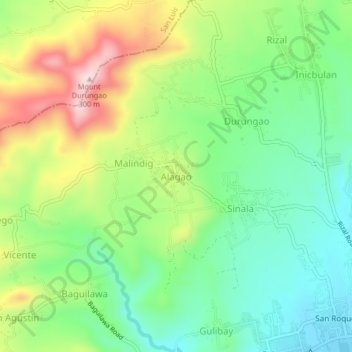
Name: Alagao topographic map, elevation, terrain.

Location: Alagao, Bauan, Batangas, Calabarzon, 4201, Philippines (13.78819 120.94721 13.82819 120.98721)

Average elevation: 128 m

Minimum elevation: 10 m

Maximum elevation: 324 m

Other topographic maps

Click on a map to view its topography, its elevation and its terrain.

Catalina Lake

Philippines > Batangas > Bauan

Average elevation: 85 m

Manghinao River

Philippines > Batangas > Bauan > San Andres

Average elevation: 25 m

Gear up for your next adventure:

🩹Moleskin Blister Pads - Direct protection for painful foot pressure points
🧤Thermal Hiking Gloves - Grip-enhanced gloves for cold-weather altitude trekking
🏕️Camping Hammock - Integrated protection for sleeping between trees
🛶Kayak Dry Bag - Waterproof storage for kayaking adventures
🥾Lightweight Hiking Shoes - Comfortable shoes for day hikes

As an Amazon Associate, this site earns from qualifying purchases at no extra cost to you.