Geolocate

San Marcos topographic map

Click on the map to display elevation.

About this map

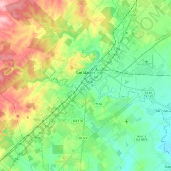
Name: San Marcos topographic map, elevation, terrain.

Location: San Marcos, Hays County, Texas, 78666, United States (29.77658 -98.01213 29.96059 -97.84196)

Average elevation: 208 m

Minimum elevation: 148 m

Maximum elevation: 323 m

Other topographic maps

Click on a map to view its topography, its elevation and its terrain.

Driftwood

United States > Texas > Hays County

Average elevation: 319 m

Henly

United States > Texas > Hays County

Average elevation: 405 m

Henly

United States > Texas > Hays County

Average elevation: 405 m

Yell

United States > Texas > Hays County

Average elevation: 403 m

Driftwood

United States > Texas > Hays County

Average elevation: 319 m

Gear up for your next adventure:

🦯Trekking Poles - Reduced impact on joints for steep topographic climbs
Lightweight Backpacking Tent - Compact tent for efficient hiking trips
Camping Tent - Weather-resistant tents suitable for 2 to 6 people
Lightweight Camping Tent - Portable shelter optimized for Canadian backcountry camping
🪑Insulated Seat Pad - Protect your seat from cold rocks and wet logs

As an Amazon Associate, this site earns from qualifying purchases at no extra cost to you.