
Thank you for supporting this site ❤️
Make a donation
Make a donation
Gear up for your next adventure:
As an Amazon Associate, this site earns from qualifying purchases at no extra cost to you.
Bossoroca topographic map
Click on the map to display elevation.
Thank you for supporting this site ❤️
Make a donation
Make a donation
Gear up for your next adventure:
As an Amazon Associate, this site earns from qualifying purchases at no extra cost to you.
About this map
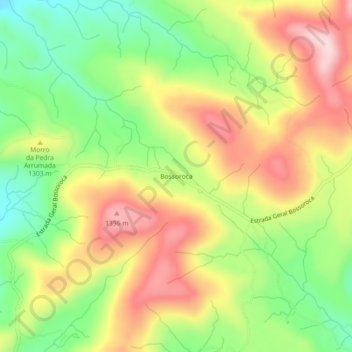
Name: Bossoroca topographic map, elevation, terrain.
Location: Bossoroca, Urupema, Santa Catarina, Brasil (-28.03671 -49.97153 -27.99671 -49.93153)
Average elevation: 1,276 m
Minimum elevation: 1,142 m
Maximum elevation: 1,417 m
Thank you for supporting this site ❤️
Make a donation
Make a donation
Gear up for your next adventure:
As an Amazon Associate, this site earns from qualifying purchases at no extra cost to you.