Geolocate

Dahegam topographic map

Click on the map to display elevation.

Dahegam

Dahegam is located at 23°10′N 72°49′E / 23.17°N 72.82°E / 23.17; 72.82. It has an average elevation of 73 metres (239 feet).

Wikipedia (CC-BY-SA 3.0)

About this map

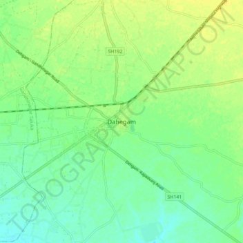
Name: Dahegam topographic map, elevation, terrain.

Location: Dahegam, Dehgam Taluka, Gandhinagar, Gujarat, 382305, India (23.12819 72.78233 23.20819 72.86233)

Average elevation: 76 m

Minimum elevation: 66 m

Maximum elevation: 86 m

Gear up for your next adventure:

🧢Sun Hat - Wide-brim hat for sun protection
💧Reusable Water Bottle - Durable water bottles for hydration on trails
🐕Hiking Dog Pack - Let your canine companion carry their own water and food
🧴Insect Repellent - Protect yourself from bugs during outdoor adventures
🛰️Satellite Messenger - Emergency communication for areas with no cell service

As an Amazon Associate, this site earns from qualifying purchases at no extra cost to you.