Geolocate

Frelighsburg topographic map

Click on the map to display elevation.

About this map

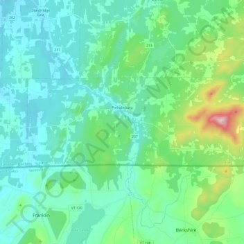
Name: Frelighsburg topographic map, elevation, terrain.

Location: Frelighsburg, Brome-Missisquoi, Quebec, J0J 1C0, Canada (45.01510 -72.92954 45.07687 -72.69166)

Average elevation: 182 m

Minimum elevation: 68 m

Maximum elevation: 692 m

Brome-Missisquoi trails, hiking, mountain biking, running and outdoor activities

Other topographic maps

Click on a map to view its topography, its elevation and its terrain.

Lac Gale

Canada > Quebec > Brome-Missisquoi > Bromont

Average elevation: 193 m

Riceburg

Canada > Quebec > Brome-Missisquoi > Stanbridge East

Average elevation: 78 m

Knowlton

Canada > Quebec > Brome-Missisquoi > Lac-Brome

Average elevation: 234 m

Glen Sutton

Canada > Quebec > Brome-Missisquoi > Sutton

Average elevation: 272 m

Gear up for your next adventure:

🧣Evaporative Cooling Towel - Beat the heat during intense summer climbs
🔥Camping Stove - Portable stoves to cook outdoors with ease
🛁Quick-Dry Microfiber Towel - Space-saving towel that dries rapidly on the move
📷Outdoor Action Camera - Capture high-elevation views and rugged adventures
🧴Insect Repellent - Protect yourself from bugs during outdoor adventures

As an Amazon Associate, this site earns from qualifying purchases at no extra cost to you.