
Make a donation
Gear up for your next adventure:
As an Amazon Associate, this site earns from qualifying purchases at no extra cost to you.
Tengboche topographic map
Click on the map to display elevation.
Make a donation
Gear up for your next adventure:
As an Amazon Associate, this site earns from qualifying purchases at no extra cost to you.
Tengboche
Tengboche is a midway station on the trail to the base camp for the mountain climbers of Mount Everest and other peaks of over 8,000 metres (26,000 ft) elevation; all these areas form part of the entire Khumbu region up to Tibet border with an area of 1,148 square kilometres (443 sq mi) encompassing Sagarmatha National Park. In the Khumbu region of Nepal, the monastery is strategically placed on the way to Everest base camp and thus attracts large number of tourists from all parts of the world. During the spring season, hill slopes around Tengboche are covered with flowering rhododendrons.
Make a donation
Gear up for your next adventure:
As an Amazon Associate, this site earns from qualifying purchases at no extra cost to you.
About this map
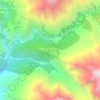
Name: Tengboche topographic map, elevation, terrain.
Average elevation: 3,936 m
Minimum elevation: 3,215 m
Maximum elevation: 4,970 m
Make a donation
Gear up for your next adventure:
As an Amazon Associate, this site earns from qualifying purchases at no extra cost to you.