
Thank you for supporting this site ❤️
Make a donation
Make a donation
Gear up for your next adventure:
As an Amazon Associate, this site earns from qualifying purchases at no extra cost to you.
Kraśnik topographic map
Click on the map to display elevation.
Thank you for supporting this site ❤️
Make a donation
Make a donation
Gear up for your next adventure:
As an Amazon Associate, this site earns from qualifying purchases at no extra cost to you.
About this map
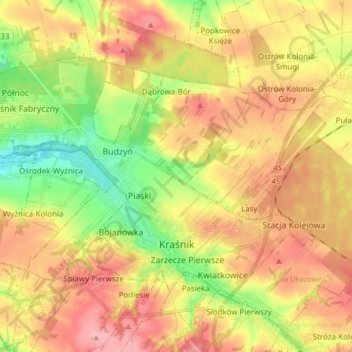
Name: Kraśnik topographic map, elevation, terrain.
Location: Kraśnik, Kraśnik County, Lublin Voivodeship, Poland (50.91061 22.13682 50.97629 22.29015)
Average elevation: 229 m
Minimum elevation: 179 m
Maximum elevation: 278 m
Thank you for supporting this site ❤️
Make a donation
Make a donation
Gear up for your next adventure:
As an Amazon Associate, this site earns from qualifying purchases at no extra cost to you.