
Make a donation
Gear up for your next adventure:
As an Amazon Associate, this site earns from qualifying purchases at no extra cost to you.
Vega de Acá topographic map
Click on the map to display elevation.
Make a donation
Gear up for your next adventure:
As an Amazon Associate, this site earns from qualifying purchases at no extra cost to you.
About this map
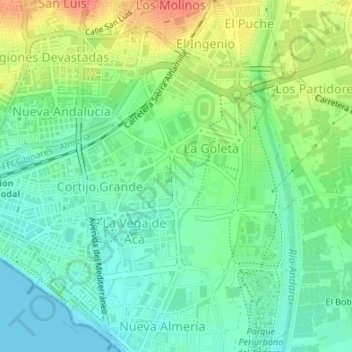
Name: Vega de Acá topographic map, elevation, terrain.
Location: Vega de Acá, La Goleta, Almería, Andalucía, 04006, España (36.82485 -2.44809 36.84485 -2.42809)
Average elevation: 19 m
Minimum elevation: 0 m
Maximum elevation: 51 m
Make a donation
Gear up for your next adventure:
As an Amazon Associate, this site earns from qualifying purchases at no extra cost to you.
Other topographic maps
Click on a map to view its topography, its elevation and its terrain.
Alborán
En su Diccionario Geográfico-Estadístico-Histórico de 1845, Pascual Madoz describe la isla: «El terreno es raso, arenisco y sin ninguna elevación sensible, cubierto de maleza parecida a la que se cría a las orillas del mar: en la parte meridional tiene un surgidero, donde suelen fondear de 25 a 30 brazas…
Average elevation: 0 m