Geolocate

Pico Chistau topographic map

Click on the map to display elevation.

About this map

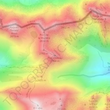
Name: Pico Chistau topographic map, elevation, terrain.

Location: Pico Chistau, Benasque, La Ribagorza, Huesca, Aragón, España (42.68355 0.43983 42.68365 0.43993)

Average elevation: 2,542 m

Minimum elevation: 2,088 m

Maximum elevation: 2,889 m

Other topographic maps

Click on a map to view its topography, its elevation and its terrain.

Ibón de la Escarpinosa

España > Aragón > Benasque

Average elevation: 2,289 m

Valle de Benasque

España > Aragón > Benasque

Average elevation: 2,090 m

Embalses de Estós

España > Aragón > Benasque

Average elevation: 1,652 m

Valle de Benasque

España > Aragón > Benasque

Average elevation: 2,090 m

Gear up for your next adventure:

Camping Coffee Maker - Brew fresh coffee anywhere on the topographic map
👟Trail Running Shoes - Agile footwear for fast-paced topographic exploration
💧Hydration Bladder - Hands-free hydration solution for long treks
🥾Waterproof Hiking Boots - Boots keeping your feet dry in wet conditions
🧤Insulated Winter Gloves - Heavy-duty protection for sub-zero Canadian adventures

As an Amazon Associate, this site earns from qualifying purchases at no extra cost to you.